| on down the road we asked a waitress at a restaurant what that was. she thought it was a place to store potatoes. & after all we ARE in idaho. the license plates carry the motto: famous potatoes. |
| at 40 miles we came to ashton. many riders stopped at a restaurant there for breakfast. by the time sari & i arrived most were leaving. we checked whether the cafe had homemade pie but they didn't, so we used the restroom then went back outside & had snacks from our bike bags. while i was walking across the parking lot a fellow drove by in a car, rolled down his window, & handed me a $5 bill. he said that he'd seen our group on TV the night before & wanted to contribute to the breast cancer fund. judith was telling me later that a woman gave her a $20 bill today for the cancer fund. it's heartwarming for us to have people responding in such a positive way to our trek to raise funds to fight cancer. |
| at the outskirts of ashton we turned north onto US route 20. we rode on it all the way to w.yellowstone, some 55 miles. it had lots of traffic--many, many trucks, many of them huge trucks, & of course oodles of recreational vehicles of every size & description with every piece of vacation gear you can imagine strapped on top or on the back. the shoulders of the road were often very rough or mostly covered with gravel or debris, & sometimes very narrow, so we couldn't rely on the haven of a shoulder for biking, tho' of course it was useable much of the time. |
| the first thing we noticed about US 20 was a 7-1/2-mile climb at a 6% grade. there was nothing on our route sheets about that....& right now we're off the adventure cycling transamerica trail route, so no hint there, either. it was an unwelcome surprise to many riders. but it wasn't any teton pass either, so that was a plus. |
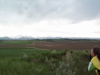
| the landscape after ashton changed dramatically from what we'd had in the morning. after ashton we entered targhee national forest. pine forests stretched for miles in all directions. often we'd come upon signs along the road that said, 'trees planted in 1981,' 'trees planted in 1996.' it was interesting to observe the size of the trees at each of these marked reforestation sites. |
| by midday the winds really picked up. much of the time they were at our backs, but later as storms started rolling in the winds got very gusty. once when sari & i were pedalling along during an especially windy spell we heard a loud crack & noted to our right that half of a 60-foot pine tree had toppled & landed on a side road. yikes that was a little close. |
| the staff people operating the sag vehicles have been busy the past couple of days. yesterday, several riders sagged up to the top of teton pass then biked downhill to drigggs. today quite a few sagged in from different points on the route. factors were road conditions, length of today's ride, & the weather, which got a little iffy by afternoon. |
| speaking of weather, at about mile 75 sari & i decided that the rain showers that had been dousing us lightly a few times were about to get more serious, so we pulled into a little restaurant. we found a table near the window & proceeded to sit there for 45-60 minutes watching very strong & gusty winds blow rain into the window. we found out later that there really hadn't been that much rain, but enough to pelt the window pretty thoroughly. once there was a bright lightning bolt & immediate loud thunder clap. we were so glad to be sitting there sharing our little BLT on wheat. (no pie at this spot.) i had an extra treat at this place; while i sat waiting for our order to be delivered a huge chocolate lab came over & laid at my feet so i could pet him. he evidently belonged to the family that runs the restaurant. |
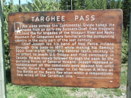
| finally sari & i ventured outside & got back on route. the skies cleared & the sun even began shining. the winds had decreased, but were still mostly at our backs. we rode up over targhee pass (again the continental divide, tho' this time just over 7000 feet). riding over the pass wasn't half the challenge that riding up the hill out of ashton had been earlier in the day. |